viz.
Visual Rhetoric - Visual Culture - Pedagogy
Site informationRecent Blog Posts
|
Google Earth Pedagogies: A Survey of Pedagogical Applications
Submitted by Laura T. Smith on Mon, 2010-02-15 11:33
(Image Credit: Google LitTrips) As I’ve been previewing Google Earth educational applications on the web, I’ve noticed that while many disciplines (science, geography, history) are using Google Earth to engage students and invite them to create within the software, applications for the English classroom (at least those that are featured and discussed on the web) overwhelmingly take the form of teacher-made presentations. I imagine that this tendency speaks to an ongoing conservatism about the design of writing assignments, a desire to retain the five-page paper as the product of the literature and writing classroom. In a video presentation that I’ll discuss later in this post, Sean McCarthy, a graduate student at the University of Texas, admits that there may, in fact, be an “amateurism” that attends writing in the Google Maps environment, but suggests that perhaps there are some benefits to this amateurism. This quality, he suggests, may open up a level of analytical adventuresomeness that the more formal structure of the essay quashes. I’m interested in this suggestion, but before I explore it further, I want to address some more common uses of Google Maps and Google Earth technologies in the literature and writing classroom. I’ve noticed that the use of these technologies takes three main forms: Mapping as a Presentation Tool, Mapping as an Analytical Tool, and Mapping as a Writing Tool. Of course, these uses overlap, but the discrete categories generally reflect the way the software is actually being used in the classroom.
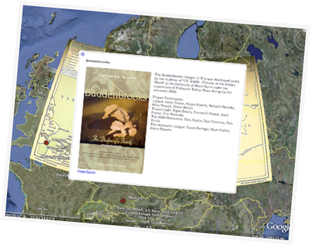
Mapping as a Presentation Tool As I mentioned above, presentations are overwhelmingly the primary, much-evidenced use of Google Maps and Earth technologies in the literature classroom. The Google for Educators site offers a collection of Google LitTrips as their recommended idea for using Google Earth in the English classroom. The LitTrips include maps of The Narrative of the Captivity and Restoration of Mary Rowlandson, James Joyce’s Portrait of the Artist as a Young Man, and Thomas Mann’s Buddenbrooks. In the latter case, the LitTrip was created by German literature students at Notre Dame, but this student-created example is the exception. The Google Earth Education Community, run by David Herring, a long-time teacher at University High School in Tucson, Arizona, similarly focuses on presentations, providing instructions for teachers to build presentations and a space for users to share their Google Earth presentations. The Google Earth presentations on Herring’s site include “The Life and Works of Jane Austen,” “Locations in Shakespeare’s Plays,” as well as maps for William Least Heat-Moon’s Blue Highways and River Horse, and Tennessee Williams’ A Streetcar Named Desire. While these presentations offer useful geospatial conceptualizations of literary works, they do not take advantage of the technology’s capacities for encouraging students to think and write in new and networked mediums. Mapping as an Analytical Tool In the aforementioned video presentation on Google Map pedagogies, University of Texas graduate student Sean McCarthy explains uses of Google Maps that extend far beyond getting directions. McCarthy shows how students can use the maps' built-in analytical tools such as the terrain map, satellite map, and street view, as well as the optional “overlays,” including articles from Wikipedia, photos from Panoramio, and video from YouTube to analyze geographical and social spaces and their online construction. He suggests that students might be divided into groups to examine a city, its neighborhoods, its layout, its public transportation and other services, its parks and greenspace, and its history using such user-generated data. He also notes that such an examination requires students to examine the rhetorical construction of Google Maps itself. Which areas show street views? Which areas include large amounts of user-generated content, such as links to Wikipedia articles and YouTube clips? Mapping as a Writing Tool While the above example engages students directly with maps, it stops just short of asking students to actually create compositions in dialogue with these technologies. McCarthy has a number of suggestions for how to get students writing in Google Maps. Here are just a few:
As is evident in the last assignment described above, composing in Google Maps places students’ writing into a socially networked environment. McCarthy joins many composition scholars, including Sharon Crowley and Michael Stancliff, when he argues that placing students’ writing into contexts that extend beyond the classroom enriches the compositional activity and connects students to audiences, which raises the stakes of the writing activity. He further argues that creating and sharing content is, indeed, the way students are increasingly accustomed to writing: according to McCarthy, 60% of all 19-year-olds publish on the web every day through social media outlets such as Facebook. While composition and literature instructors may prefer the familiar, formal, linear structure of the traditional essay, McCarthy's findings suggest that the "amatuerish" writing student sometimes produce when composing in digital mediums in fact bespeaks the quality and complexity of their research and analytical connections. There are more Google Maps- and Google Earth-related assignments indexed in the DWRL’s database of technology-based lesson plans. If you plug “Google Maps” into the site’s search bar, you’ll easily turn them up. Tags:
|
TagsRecent comments
|
Comments
DWRL Geo-Everything Project Group
The new DWRL Geo-Everything Project Group has been at work all year on researching and developing a variety of pedagogical applications for Google Maps and Google Earth.
Project Leaders Caroline Wigginton and Jeremy Dean recently led a Google Earth Workshop that introduced some of the Group's research thus far and included an overview on using Google Spreadsheet Mapper, which allows users to brand placemark templates and enter data for personalized maps and tours in Google Earth and Google Maps. An agenda and handouts with step-by-step instructions are available at the Workshop link above; tutorials are also available at Google Earth Outreach. A video of the workshop will soon be available through the DWRL Communications Project.
Project leaders and members Catherine Coleman and Shelley Manis have been generating an archive of Google Earth and Google Maps lesson plans that is available, as Laura points out, through DWRL's Pedagogy Lesson Plans.
Google Earth finds new hominid!
Check out the role that Google Earth played in the discovery of a new hominid specicies in South Africa:
"Dr. Berger said the path to the discovery began over the Christmas holidays in 2007 when he began using Google Earth to map caves in the Cradle of Humankind. On a recent visit to his office, he rotated Google Earth images of the dun landscape on his desktop, showing how he spotted the shadows and distortions of the earth that gave clues to the location of caves, often topped with wild olive and white stinkwood trees."
NY Times, 8 April