viz.
Visual Rhetoric - Visual Culture - Pedagogy
Site informationRecent Blog Posts
|
The Secret History of Lines
Submitted by Laura Thain on Mon, 2012-11-05 13:53
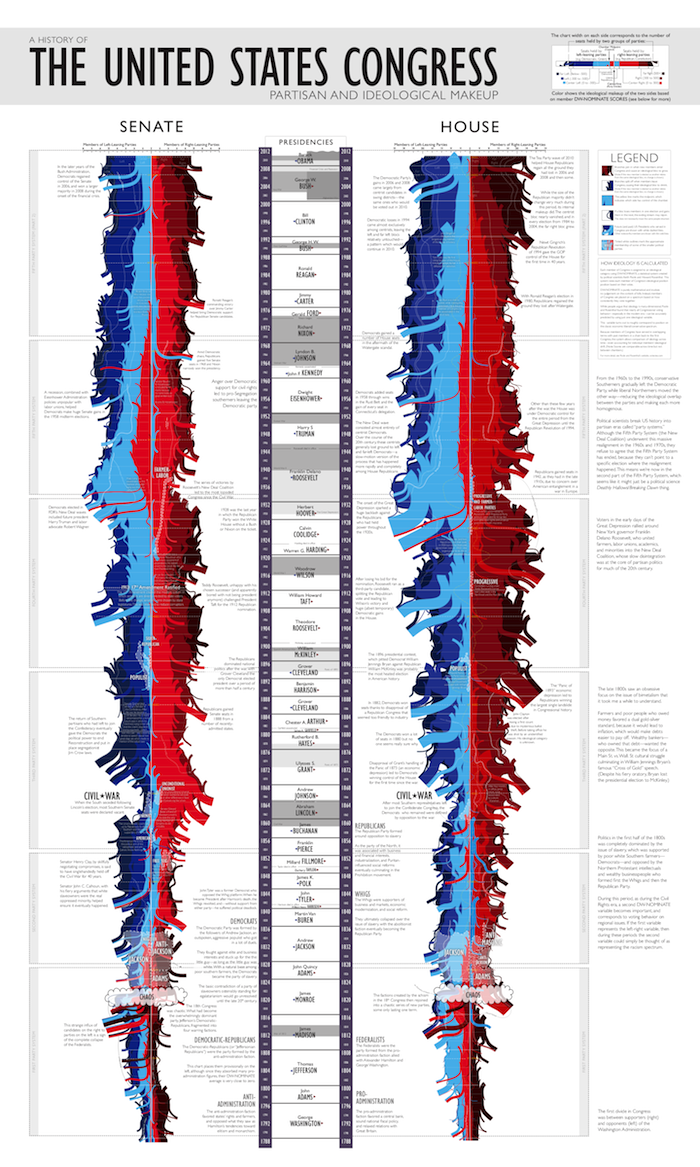
Image Credit: Colin Stearns With 24 hours to go, media outlets projecting the outcome of election day are covered in geographical maps of states and counties painted starkly in red and blue. I’ve enjoyed the responses of armchair intellectuals like Randall Munroe, who playfully reinterprets the red/blue divide to create a complex and comprehensive visual history of the Republican and Democratic parties. The proliferation of regional and ideological divides across multiple media this week urged me to explore two important questions in visual rhetoric: What does it mean to visualize a geographical boundary? And what does it mean to visualize an invisible line? (I would be remiss not to mention the enormous amount of border studies that exist in postcolonial and Anglophone literature and criticism—but today on viz I will try to confine myself to a discussion of the visualization of intranational borders.) Here to help me is the photography of Colin Stearns, Assistant Professor of Photography at Parsons. Stearns' current project is photographing the Mason-Dixon line in order to capture "this border of cultural distinction at the places of its occurence." Each of his photographs contain the invisible interstate line somewhere within their composition. I'll also put Stearns in dialogue with William Byrd II, the 18th century commissioner of the colonial line between North Carolina and Virginia. First, a bit about the Mason-Dixon line’s place in the historical record and in our national imagination. In his artist’s statement, Stearns recognizes the Mason-Dixon line as a “cultural barrier,” a particularly apt term considering the large discrepancy between the actual and the imagined political effect of the drawing of the line. Surveyed between 1763 and 1767, the line’s chief purpose was to settle a land dispute between the Penns of Pennsylvania and the Barons Baltimore of Maryland. The ensuing line established a firm boundary between the colonies of Maryland and Pennsylvania and Delaware as a satellite colony of Pennsylvania with varying levels of independent government in the colonial period. (Delaware’s history of strong government influence from the dynastic governors of both Maryland and Pennsylvania no doubt contributed to the eagerness of its home-grown politicians to be the first to join, as an independent state, the newly formed United States in the 1780s).
Image Source: Wikipedia But at no point during the colonial period did the Mason-Dixon serve as an actual dividing line between slave and non-slave colonies because there simply did not exist such a delineation. Laws explicitly prohibiting slavery, with the noted exception of Vermont, did not exist in the colonial period. (Vermont’s Constitutional Charter, which declared Vermont separate from New Hampshire early in the Revolutionary War, is one of, if not the first, abolishments of slavery among the British colonies of North America.) It was not until a full two decades after the Mason-Dixon was drawn that Pennsylvania outlawed slavery (1780); Connecticut, Massachusetts, Rhode Island, and New Hampshire did the same shortly after the recognition of the new Republic in 1783-1784. New York and New Jersey took decades to follow suit (1799 and 1804, respectively), and the line cannot be argued to have the smallest significance in slave/free state designations west of the Appalachians. Delaware, firmly north of the dividing line, did not abolish slavery until the 13th amendment was passed in 1865. Clearly, the Mason-Dixon line had no correlation to the practice of slavery in the colonial period. It was not until the 19th century—during Congressional debates culminating in the Missouri Compromise of 1820—that the Mason-Dixon line began to symbolize a politicized North/South divide that claimed slavery as its principle cultural difference. Image Credit: Wikipedia So how can we read the Mason-Dixon Line’s historical significance with more care? How can this reading help inform Stearns’ project and in general expand our conception of the visual representations of political boundaries? I answer this question by going even further back into the colonial 18th century of America and examining the first significant commissioned survey of a colonial boundary—that of North Carolina and Virginia, led by failed governor hopeful and plantation aristocrat William Byrd II of Virginia.
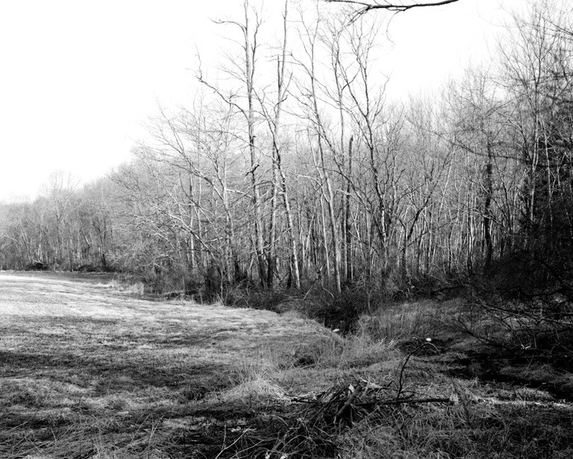
Byrd published two histories of his 1728 excursion, both of which have become indispensible primary sources of both public and private life in the 18th century colonial South. (Byrd’s secret diary, which was decoded only in the 20th century, gives a particularly detailed glimpse into the private thoughts and cultural attitudes of a colonial husband, land owner, and slave holder.) The History of the Dividing Line Betwixt Virginia and North Carolina contains an official account of the survey, but the more interesting text is the semi-parodic and much more candid Secret History of the Dividing Line, which Byrd drafted for a small circle of political elite in England. It is of no small significance that it is in the Secret History, not the official account, that Byrd spends considerable time describing difference between the Virginians, who he saw as the gentile elite of the English colonies in North America, and the North Carolinians, who he describes as disorganized, uneducated, and culturally inferior. In addition, the Secret History also emphasizes that the initiative to survey the line originated within the councils of the colonies themselves, not from a royal entity. The importance of colonial sovereignty in the exercise of drawing the dividing line receives great rhetorical attention, and so the end result of these two conflicting impulses in the text is that while the North Carolinians are culturally discredited, their presence in the process of boundary-making is essential to the legality of the line formed. Byrd is thus able to legitimize the survey expedition both culturally and politically, strengthening his claim to the validity of its existence and the importance of the endeavor. That Byrd considered these elements to belong to a “secret” history—that is, a suppressed or forgotten one—is in no small way related to the immense amount of cultural labor that surrounds the border-making project, and this is the same type of cultural labor that political factions exert and popular imagination perpetuates in the case of the Mason-Dixon line. The line became a crucial piece of evidence for both secessionist and unionist rhetoric during the various secession crises of 1820-1840, and of course, played a role in the ultimate dissolution of the Union in 1861. Beginning in the 1820’s, the survey stood no longer as a triumph of scientific instrumentation (Mason and Dixon’s survey techniques later led to the first accurate calculations of the earth’s density) in drawing an arbitrary geographical border or a legal precedent for settling land disputes between colonies and therefore states. Instead, the line was used to argue that political borders reflected an innate or organic cultural difference between each side’s respective constituents, and thus, strengthened the legitimacy of the artificial divide. And of course, unlike the lines drawn by the Missouri Compromise (1820) and the Kansas-Nebraska Act (1854), the Mason-Dixon line exists in physical representation, with a stone marker bearing the arms of both Pennsylvania and Maryland placed every 5 miles along the surveyed line. And it is artist like Stearns who reveal and interrogate the labor of creating these boundaries. Stearns’ photography does so by several means. First, he utterly avoids the iconic line-markers, choosing instead to allow a mixture of organic and architectural details to connect the physical composition of the photographs to the theoretical subject matter. In highlighting these two types of “line-drawing,” Stearns seems to emphasize both the political border’s reliance on a rhetoric of organic divide (that is, that the cultural distinctions between populations predate the proverbial drawing of a line in the sand) but its essentially constructed nature. Take, for example, this photo:
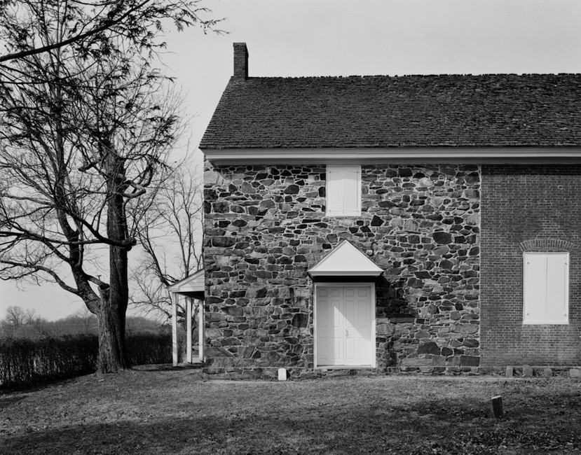
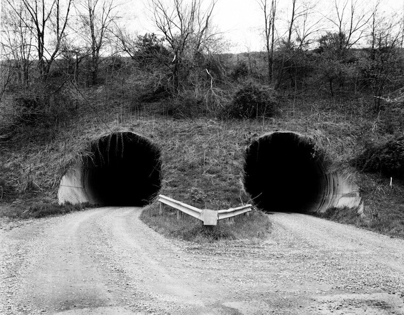
Image Credit: Colin Stearns Sometimes his photos make a primarily architectural argument:
Image Credit: Colin Stearns
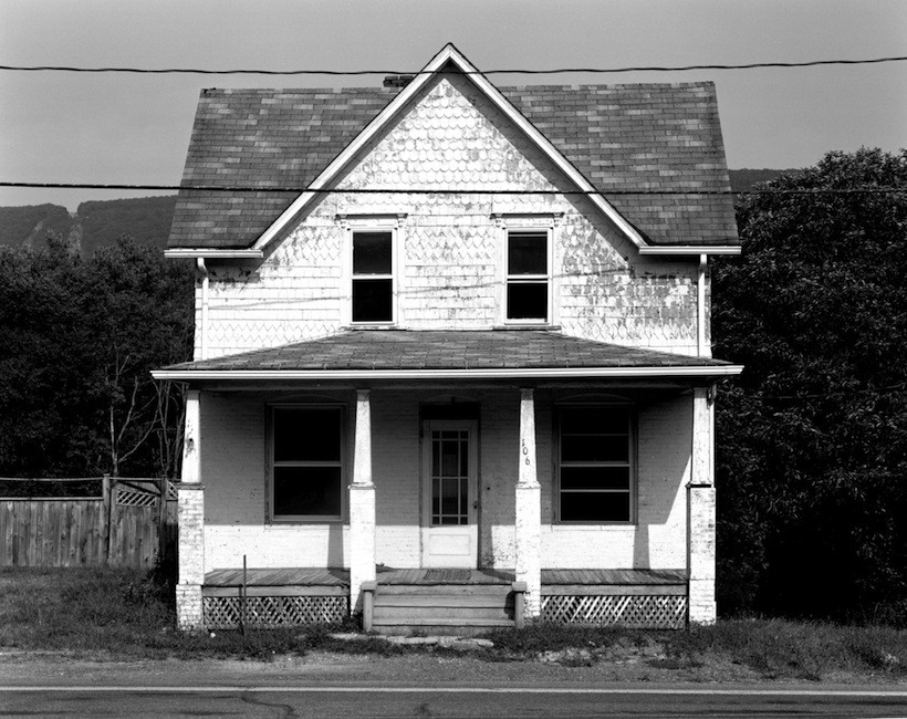
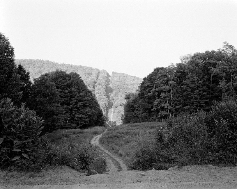
Image Credit: Colin Stearns And sometimes they seem to make an organic one:
Image Credit: Colin Stearns
Image Credit: Colin Stearns But almost always, they combine elements of both.
Image Credit: Colin Stearns If I can get away with making overarching aesthetic claims here, I would like to posit this: the audience, in the very act of viewing these pictures with the knowledge that they are visualizations of a geographical border, searches for delineation within them, even as they know those delineations are artificial. The audience thus becomes both aware of political boundaries as a cultural construction and aware of their own complicitness in creating them; the pieces no longer become a mere accusation of the stark black-and-white artificiality of manmade divides but an interrogation into the process by which we as members of society participate in the creation and perpetuation of those boundaries, even when they become oppressive.
Munroe's Complex Visual History of the US Congress. Image Credit: XKCD The lines I’ve examined today helped to create and sustain a cultural and geographical border between the North and the South and designate them as opposing ideological spaces, creating a (bi)polarized and (bi)polarizing political rhetoric that has dominated American politics since the splintering of the Democratic Republican party and Jackson’s presidency during the aforementioned 18th Congress of the 1820’s (but that’s another long story). Where might we go further with this investigation? Can we use extend these arguments to describe how political boundaries function in 21st century America? Does, for instance, our current connection between political boundary and ideological identity depend less upon regional dichotomies (North/South, East Coast/West Coast) and more upon population density (urban/rural)? How does this change how we might read these invisible lines? |
TagsRecent comments
|
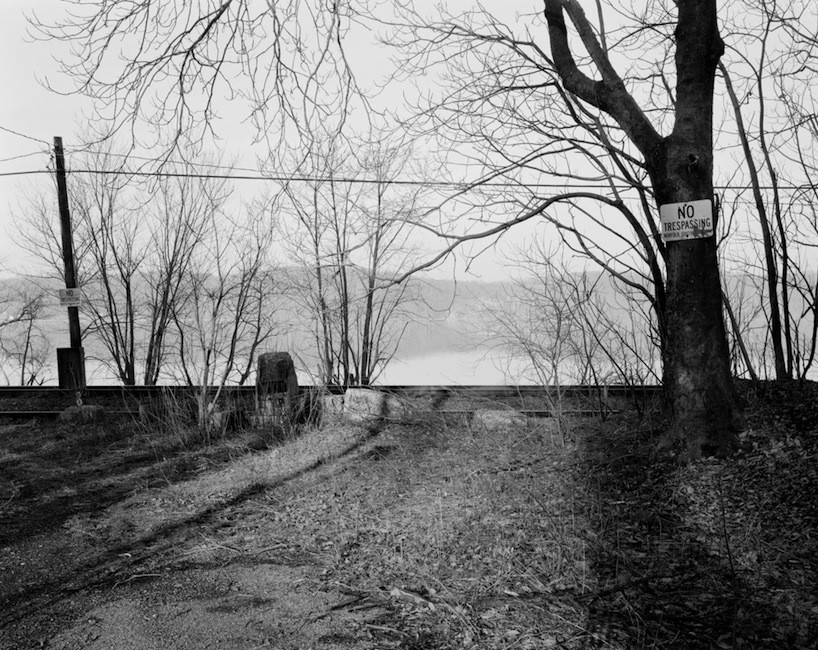
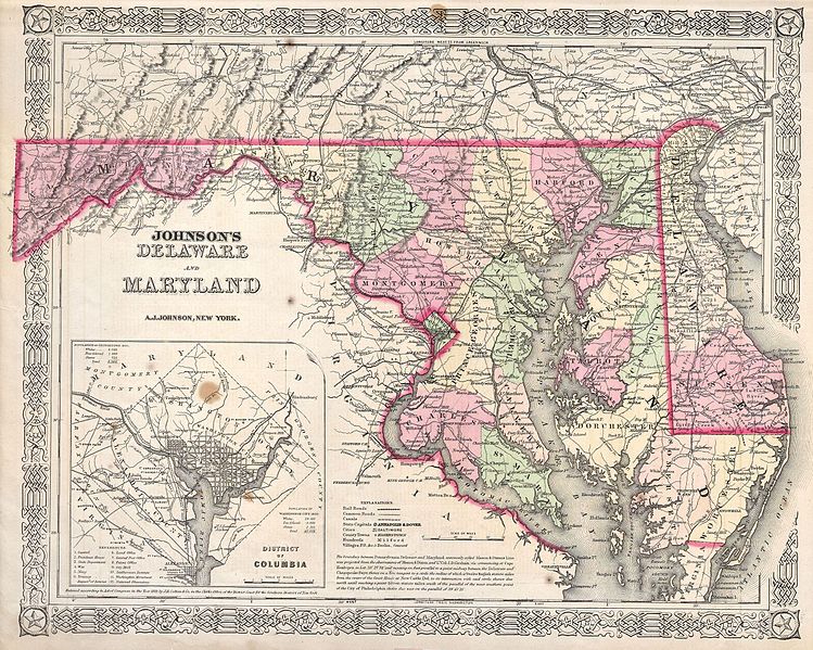
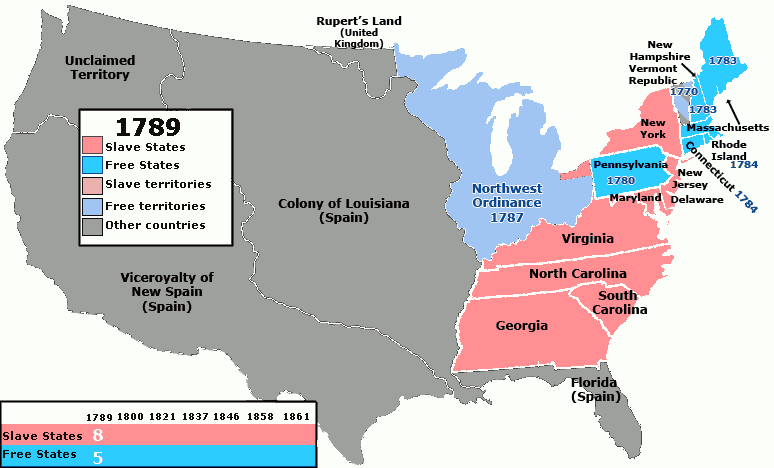
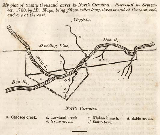 Image Credit:
 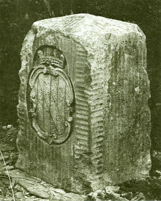 Image Credit:
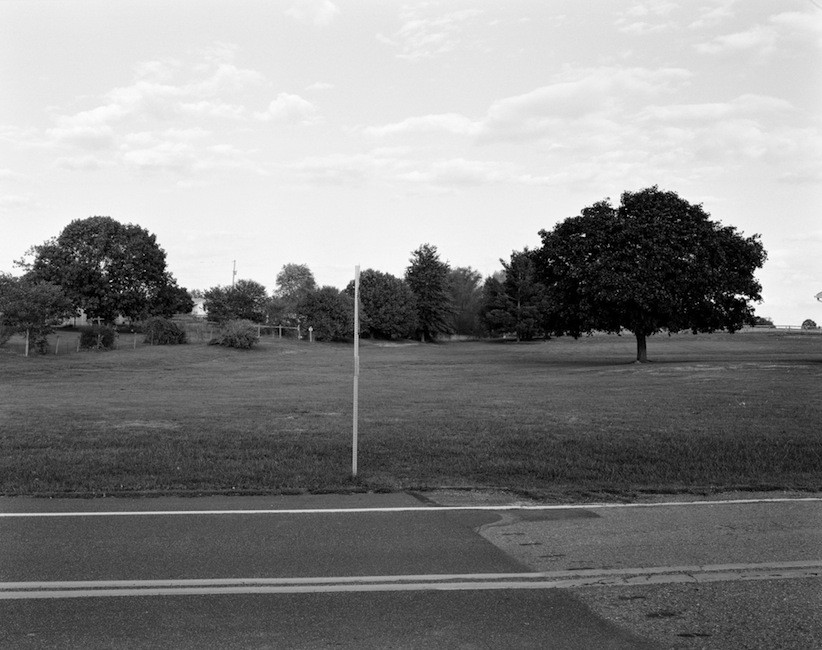
Comments
Awesome, as always, LT.
Awesome, as always, LT.