viz.
Visual Rhetoric - Visual Culture - Pedagogy
Site informationRecent Blog Posts
|
Renaissance ItalyCheck Out this Imaginative Map of Renaissance Venice
Submitted by Jay Voss on Wed, 2013-02-27 10:00
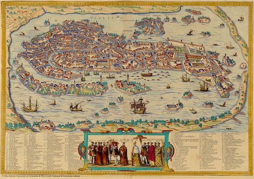
(Image credit: The Hebrew University of Jerusalem) I was reading Galileo the other day when I became interested in Renaissance Venice (the place had sublime music, visual arts, and all the culture that comes with the great flowerings of these things), and a few Google searches later I found myself staring at the map above for about 20 minutes. (Click here for a larger copy.) The map was drawn by Bolognino Zaltieri in 1565. Now, it’s already allergy season here in central Texas and I admit that I feel as though I’m on allergy meds without having even taken any, so my fascination with the map could be due to various things beyond my own intellect, however, you’ve got to admit – this map is awesome. It’s just crazy to imagine living amongst one of those waterways several hundred years ago. How about all the bridges? And do you notice that a pedestrian going from one mini-island to another might have to plan their trip in advance, as not every mini-island is connected to its peers? And then, of course, you wonder how it was all built without the aid of gasoline-powered construction tools. I thought I’d share it all with you. It’s just mesmerizing how a city built upon a marsh contains so many things, and how a mapmaker was able to portray segmented happenings and city life.
|
|
Recent comments
2 years 29 weeks ago
2 years 44 weeks ago
2 years 44 weeks ago
2 years 50 weeks ago
3 years 4 weeks ago
3 years 4 weeks ago
3 years 4 weeks ago
3 years 6 weeks ago
3 years 6 weeks ago
3 years 6 weeks ago