viz.
Visual Rhetoric - Visual Culture - Pedagogy
Site informationRecent Blog Posts
|
Google Earth and Bahrain: Surveillance for AllBy Lauren Mitchell
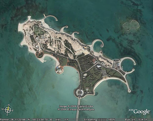
What makes Google Earth so revolutionary is that it gives the ordinary citizen access to information about the location of military and governmental buildings as well as the residences of those in power that used to be available only those with satellite access. The threat here is not that citizens might use this information to attack these locations, but that this information could be used as political ammunition. Google Earth enables anyone to monitor land-use, something that is usually seen as a benign activity. However, it may have grave political and social repercussions. For example, via Google Earth you can see what’s being built and where it’s being built, who lives where and in what kind of home, what land is being used for, the spatial relationship between different types of land-use, and how much land is being used for a particular purpose or by a particular person or agency. (Monmonier 174) The significance of this surveillance of land is exhibited most clearly in the controversial uses of Google Earth in Bahrain to make arguments about the royal family’s use of this island-country’s scarce land. There are many arguments, based on Google Earth images alone, that the royal family is misusing and hording land in Bahrain. And again, Google Earth’s use of photography and maps makes these arguments very convincing. The conflict in Bahrain is an interesting example of possible uses of Google Earth as surveillance, its contribution to a more democratic or egalitarian society, and problems inherent in the use of satellite images as evidence. Bahrain is perfectly set up for taking advantage of Google Earth because one of the major issues in the country is a housing shortage. A New York Times article reported that there is a chronic housing shortage among the Shiite majority, who also make up a larger portion of the poorer citizens of the country. (MacFarquhar) Apparently there are 27,000 applications pending for subsidized government housing. The article cited the experience of one man with a good job as a computer engineer who can’t afford a house of his own, so he shares his father’s house with his siblings and their families. One nuclear family lives in each room. Stories like this make it clear why Bahraini’s began to survey their country very carefully when Google Earth first became available. People soon found images of the immense palaces and mansions owned by the Khalifa family, the country’s royal family and a part of the elite Sunni minority. The Khalifa family holds one-half of all cabinet positions as well as major posts in security services and the University of Bahrain. Under Bahraini law, the family’s spending is not subjected to public scrutiny, so analysis of their mansions is one of the only ways Bahraini citizens have to keep tabs on their royalty. Although the Khalifa’s denies it, the opposition claims that they are monopolizing available lands. (MacFarquhar)
Most interesting are the comments on “Mahmood’s Den” which clearly indicate that people feel that Google Earth gives them power and shows them the truth about their government’s activities. People immediately picked up on Google Earth as a way to keep tabs on their government and military in a way they have never been able to before. For one blogger Google Earth reveals what some were trying to hide: The best thing to do right now is spread the word about google earth. tell people you know or people you don’t even know. show them whats been going on in bahrain for the past decades. building high walls and planting tall trees isn’t going to cut it anymore; google has revealed the truth. i think that even the majority of the royal family hasn’t seen what some of there family members have done and continue to do. do it for your kids and for bahrain. (al-Yousif, “Does”) Another commenter was excited by being able to see things that didn’t appear on regular maps of Bahrain: “WoW! You can even see the “secret” air base down south that doesn’t exist on Bahrain made maps. I even spotted “secret” fighter jets on the runway!” (al-Yousif, “Does”). And Google Earth is definitely seen as a tool for revolution: “…if robin hood and his ‘merry’ men were alive, they would make great use of [Google Earth] as tool to steal from the rich and give to the poor” (al-Yousif, “Does”). The commenters also agree that Google Earth was blocked because it allowed the public to look at the palaces and the land-use situation: “ya, they have closed the Google Earth, because it was exposing everything. The dirty beaches, polluted environment and even the big luxury houses of the (ruling family). They don’t want us to tell that they are living in luxury and we are not.” (al-Yousif, “Blocked”) This comment is particularly interesting because it’s not solely concerned with the mansions of the rich; it also sees Google Earth as a way to keep track of environmental issues. Based on these comments, it is clear that these people see Google Earth as a tool to fight back against an apparently oppressive royal family that dominates control of the government, land, and wealth. Google Earth fits perfectly into the land-distribution controversy and enables them to use this evidence to challenge the overall system. The images serve as a very convincing visual argument about the land-distribution problems in Bahrain. The images are a piece of evidence that the public could not ignore, or as one commenter put it, “Some of the palaces take up more space than three or four villages nearby and block access to the sea for fishermen. People knew this already. But they never saw it. All they saw were the surrounding walls” (Doctorow). In addition to being an example of the usefulness of Google Earth in argumentation, the Bahraini land-distribution controversy is also an example of some of the problems of using satellite imagery as evidence. The PDF is the perfect illustration that, “we must ask ourselves how meaning is constructed from these images, how they are read and how they are potentially misread” (Kreuter 1). As I said earlier, questioning the veracity of photographic evidence has become commonplace, but satellite imagery like that on Google Earth still enjoys “a certain ‘empirical’ or ‘scientific’ credibility.” (Kreuter 2). The issues here are interpretation and trust: How do we verify the factuality of the readings of satellite images? Do we trust the readings that are presented? In the case of the Bahraini PDF there are several issues pertaining to trust. For example, at one point the author of the PDF claims that the scale of the areas of Bahrain in the images is the same. This is a critical aspect of the argument because the one of the main arguments is that these royal palaces are taking up the same amount of land that thousands of Bahraini’s live on in the cities, a highly damaging claim in a country with such dire land and housing shortages. If this claim about the scale is false, the argument is invalid. In addition to this issue of scale is the recognition of the locations. Some locations in the PDF are labeled by Google Earth, but others are zoomed in too far to be labeled. While it might be plausible to argue that a native Bahraini would be able to verify that the locations in the Google images are accurately identified in the PDF, for someone like me, who would have had trouble locating Bahrain on a map let alone identifying specific locations within Bahrain, the identifications made by the PDF’s author have to be taken as fact. As Kreuter notes, because the author offers evidence that is unverifiable, the result is that the author is essentially demanding that we trust his or her interpretations. There is no way for anyone without detailed knowledge of the way a particular location would appear in a satellite image would be able to counter the claims made by the PDF’s author. Along the same lines, the PDF attributes the ownership of most of these palaces to the royal family and also claims that their property is owned illegally. Although there is no way to verify this, it fits perfectly into the public’s perception that the royal family is hoarding land. So, to a certain extent, the authority of the PDF rests on the fact that its argument and evidence fit these pre-existing ideas. (Kreuter 4) This is just another example of Monmonier’s warning that “satellite imagery is vulnerable to misinterpretation and clever deceptions” (36). While many people are worrying that big-brother may be becoming a reality as we speak because of CCTV, RFIDs, and biometric identification software, Google Earth offers a way for a closely monitored public to take on the role of the observer. The uses of Google Earth in Bahrain illustrate how the power of surveillance can work in the hands of the public. However, we still must ask how much is accomplished through the observation of those in power. It seems that little has changed in Bahrain except for the spread of information—but will this information cause any tangible changes in policy in the country? If the purpose of surveillance is to monitor and control human behavior, it remains to be seen how effective the surveillance capabilities of Google Earth really are. (Monmonier 2) Additionally, evidence from surveillance sources used by the public clearly has similar problems of interpretation as surveillance used by governments. As the public becomes more educated about the rhetorical nature of interpretations of surveillance, we need to remain skeptical of surveillance presented as transparent evidence. Sourcesal-Yousif, Mahmood. “Google Earth Does Bahrain.” Weblog Entry. Mahmood’s Den. 12 Jun. 2006. 2 Dec. 2007. <http://mahmood.tv/2006/06/12/google-earth-does-bahrain/> al-Yousif, Mahmood. “Google Earth Blocked in Bahrain.” Weblog Entry. Mahmood’s Den. 7 Aug. 2006. 2 Dec. 2007. <http://mahmood.tv/2006/08/07/google-earth-blocked-in-bahrain/> Doctorow, Cory. “Bahrainis use Google Earth to spy on royals’ palaces.” Weblog entry. Boing Boing. 26 Nov. 2006. 3 Dec. 2007. <http://www.boingboing.net/2006/11/26-week/> Keuter, Nathan. “The Subjectivity of Eyes in the Sky: Understanding Remote Sensing through the Cuban Missile Crisis and the 2003 Build-Up to War in Iraq.” Seminar Paper. U of Texas at Austin, 2008. MacFarquhar, Neil. “In Tiny Arab State, Web Takes on Ruling Elite.” New York Times. 15 Jan. 2006. 2 Dec. 2007 <http://www.nytimes.com/2006/01/15/international/middleeast/15bahrain.html> Monmonier, Mark. Spying with Maps. University of Chicago Press: Chicago. 2002. |
|
 Photographs and maps have long been used to make arguments. Photographs have been used as hard evidence of someone’s guilt, of the existence of a situation, of the fact that an event took place. Maps have been used by all sorts of organizations as support for their arguments: countries use maps as propaganda to claim territories that are in dispute and assert their importance in a region, developers use maps to argue for building at a particular site, businesses use maps as advertisements. (Monmonier) Although today most people have a healthy skepticism about photographs because of widespread photo-shopping, both of these forms of evidence are still often considered indisputable. This makes Google Earth, which combines the power of the photograph and the map via satellite imagery, a form of evidence that seems all but incontrovertible. As Nathan Kreuter says, "Previously only available to the governments of major world powers, high quality satellite imagery’s new availability is a boon to non-governmental researchers, media organizations and even to private citizens savvy enough to grasp the medium’s vast potential" (1). Although no one would dispute this potential, serious concerns about the use of this technology have also emerged. The most common concerns about Google Earth come primarily from two places. Private citizens are mainly concerned about invasion of privacy, and in this age of terrorism, governments and militaries are more concerned about the use of these images by those who might want to launch an attack. However, it turns out that governments and militaries may also need to be concerned with how Google Earth enables the public
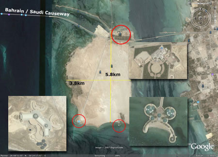 Google Earth, it seems, was made for just this sort of controversy. Google Earth has garnered a lot of attention as soon as its potential for monitoring the royal family was realized. Much of the conversation about Google Earth and the mansions can be seen on a popular Bahraini blog, “Mahmood’s Den.” Mahmood al-Yousif, who blogs about everything from politics to his garden and describes the blog as “An Arab man’s attempt at bridging the cultural gap,” encouraged his readers to use Google Earth to explore Bahrain and to post images to Flikr so that even people without the bandwidth for Google Earth could view the images. In addition to the discussion on Mahmood’s Den, is this
Recent comments
2 years 29 weeks ago
2 years 44 weeks ago
2 years 44 weeks ago
2 years 50 weeks ago
3 years 4 weeks ago
3 years 4 weeks ago
3 years 4 weeks ago
3 years 6 weeks ago
3 years 6 weeks ago
3 years 6 weeks ago