viz.
Visual Rhetoric - Visual Culture - Pedagogy
Site informationRecent Blog Posts
|
geographyWallace as Visual Experience
Submitted by Eric Detweiler on Fri, 2012-04-06 08:00
"David Foster Wallace mii Playing Tennis" — Image Credit: Nick Maniatis, via Kottke.org My first spring in Texas left me nostalgic for my Kentucky roots. This, of course, meant I’ve spent the last few weeks watching entirely too much March Madness. For Kentuckians, without a single professional sports team to call their own—and without Texas-sized performance and investment in college football—college basketball is a powerful source of sports identity. The showdown between the University of Louisville and the University of Kentucky in this year’s Final Four was an epic, almost state-shattering event. I’m not much interested in halftime banter or commercial breaks, however, so the last few weeks have also included a good deal of channel surfing. As I surfed, I found myself catching glimpses of another sport I’ve always wanted to watch more of but never have: tennis. My potential interest in tennis has nothing to do with fond remembrances of my single season as a high-school tennis player (I was horrible). It’s a theoretical interest that is largely indebted to David Foster Wallace. Tennis figures prominently not only in Wallace’s well-known novel Infinite Jest, but in his essays.
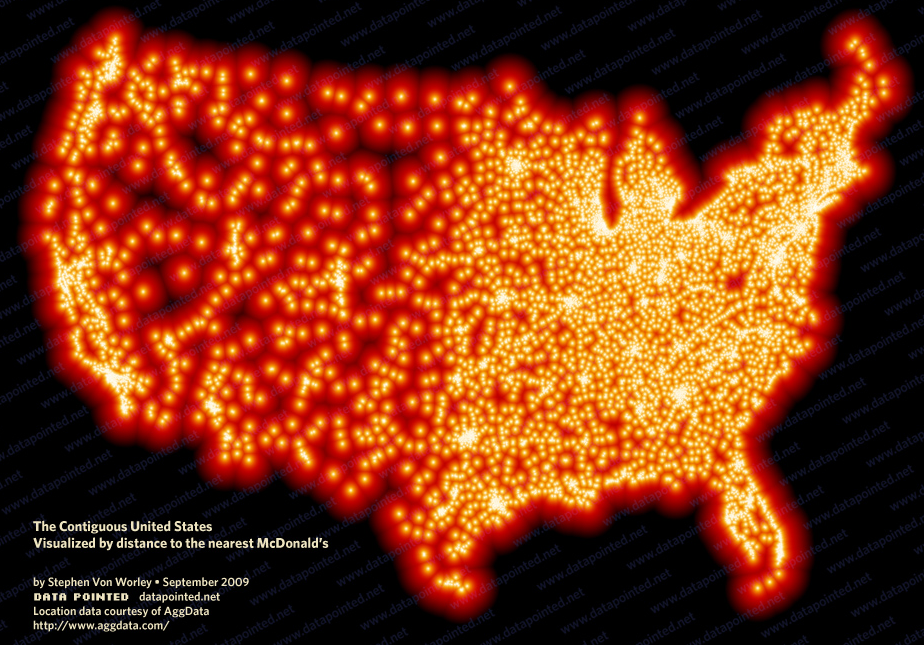
From Sea to Shining McDonald's, and Other Americas: Critical Cartography II
Submitted by Jake Ptacek on Tue, 2011-11-08 09:00
Image by Stephen von Worley Last week, I wrote about the power of cold-war era maps when it comes to visualizing Western attitudes towards the Soviet bloc, and, in the work of William Bunge, visualizing themselves. This week I want to continue my trip down critical cartography's rabbit-hole with an overview of maps that attempt to locate forms of the "American experience." How can aspects of daily life in America be represented visually? The following maps try to answer that question, in playful, political, and subversive ways. |
|

Recent comments
2 years 29 weeks ago
2 years 44 weeks ago
2 years 44 weeks ago
2 years 50 weeks ago
3 years 4 weeks ago
3 years 4 weeks ago
3 years 4 weeks ago
3 years 6 weeks ago
3 years 6 weeks ago
3 years 6 weeks ago