viz.
Visual Rhetoric - Visual Culture - Pedagogy
Site informationRecent Blog Posts
|
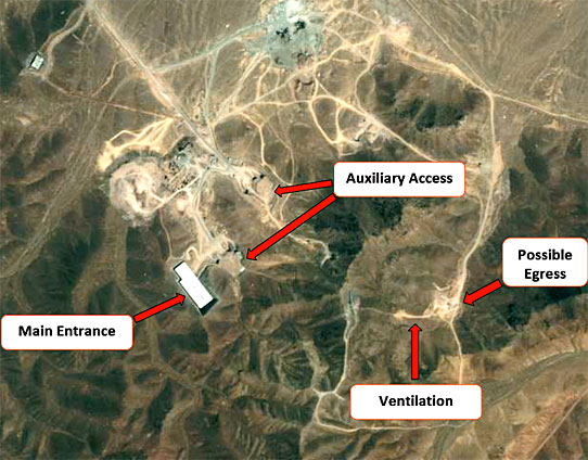
Remote SensingIranian Nuclear Facility Photo & Interpretation
Submitted by Nate Kreuter on Thu, 2009-10-01 09:30
This morning I received an automatic update message from Imaging Notes, a remote sensing (satellite imaging) trade magazine. The lead-off story was about one of the alleged nuclear material refining facilities in Iran. The image, and the annotations provided by a private company, are eerily similar to those Colin Powell used in his February, 2003 speech to the UN when he argued on behalf of the doctrine of pre-emptive war in Iraq. I point all of this out not to question the interpretation of the Iranian image, but simply to point out that as lay-people and citizens, we do not have the means to engage with the arguments presented in such images, but must take or refuse their content based with only our trust or mistrust in the party providing the image to guide us.
Remote Sensing and the Obama Inauguration
Submitted by Nate Kreuter on Wed, 2009-01-28 13:35
Much was made of the crowds that attended President Obama's inauguration in Washington, DC last week. As evidence of remote sensing's (that is, satellite image's) greater role in public consciousness, check out this image of the crowds gathered for the historic moment, shot at one-half meter resolution. (One-half, or.5, meter resolution means, more or less, that the smallest units discernible in the image are .5 x .5 meters, about the size of a person from above. The resolution is roughly equivalent on the NIIRS scale, which is the military/intelligence community's rating scale for remotely sensed image interpretability.) Increasingly news organizations are citing remotely sensed images in their reporting. Whether this is a techno-fad or provides a legitimately new and informative perspective on events, I'd be curious to hear readers' opinions on.
Image courtesy of GeoEye (click link for a larger resolution photo, as well as additional remotely sensed images) |
|

Recent comments
2 years 29 weeks ago
2 years 44 weeks ago
2 years 44 weeks ago
2 years 50 weeks ago
3 years 4 weeks ago
3 years 4 weeks ago
3 years 4 weeks ago
3 years 6 weeks ago
3 years 6 weeks ago
3 years 6 weeks ago