viz.
Visual Rhetoric - Visual Culture - Pedagogy
Site informationRecent Blog Posts
|
Google Earth Pedagogies: Beyond “That’s So Cool”
Submitted by Laura T. Smith on Mon, 2010-02-22 13:54
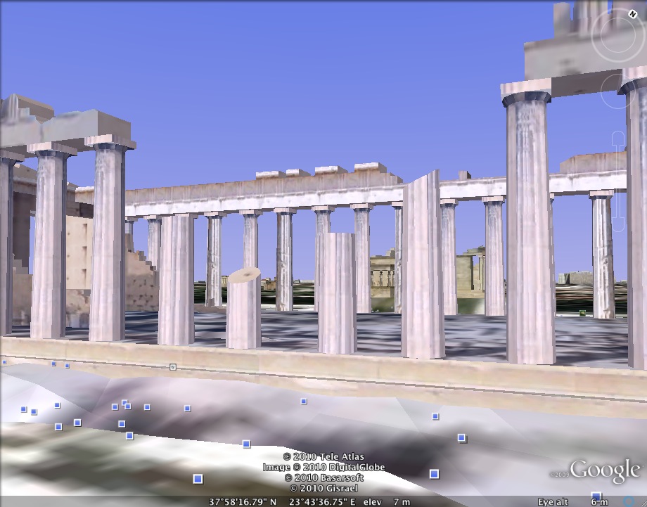
(Image credit: Image capture of the Parthenon in Athens, Greece from Google Earth) A fellow graduate student recently mentioned to me that his
rhetoric professor had used Google Maps to show classical Athens to the class. He told me, “I kept thinking how much
cooler it would have been if we were looking at it in Google Earth, walking
around down there in street view.”
Other assignments using Google Maps technology include Jeremy Dean’s “Map Three Readings,” which asks students to use a map to “draw a physical and thematic connection” between multiple readings by placing authors or characters on a map, and Eileen McGinnis’ “Mapping Galapagos,” which asks students to map landmarks and events in Kurt Vonnegut’s novel, Galapagos. McGinnis frames the map as a thinking process, not a product, at least at the outset: “Keep in mind that your map will function initially as a tool for discovering something unexpected about the novel rather than for charting the Known World.” These assignments demonstrate well how writing within maps can aid students’ invention process, prompt students to make visual, spatial, and physical connections within and across texts, and can, themselves, constitute an argument (thereby denaturalizing mapping as an authorless or objective rendering of space). Most of these assignments were created before the release of Google Earth, however, so they might be adjusted or reformulated to more fully take advantage of Google Earth’s distinct capacities, such as its capacity to show non-static data, to depict historical change, to show beautifully-rendered, 3D buildings, to travel from site to site via a user-generated animated tour, to offer various annotation options via clickable layers, and to move quickly between macro and micro views of the same landscape. While some of these features are available in Google Maps, Google Earth’s animation feature allows users to dramatize these functions, heightening their effect. Google Earth’s homepage includes a Gallery of selected tours and animations that demonstrate the technology’s advanced functions. These animations give a sense of the informational and analytical uses of features particular to Google Earth, such as 3D buildings, historical timelines, and the ability to travel. The Gallery includes tours of major world cathedrals, castles, libraries, and universities, as well as an animation of major international flight routes. Each file must be opened within Google Earth, so users must download the software, which is free and available on the same site, to view the demonstrations. It's also important to note that users must find in Google Earth's left-hand sidebar an icon that looks like a movie camera. Clicking this icon will "run" the file. As I mentioned two weeks ago, the DWRL’s Geo-Everything Group has been putting together resources to familiarize instructors with Google Earth and help them integrate it into the writing classroom. Their recent Google Earth Workshop provided a practical introduction for using Google Earth in the classroom, including tips for making basic and customized placemarks and using Google’s data template, Spreadsheet Mapper, for creating collaborative maps with “branded,” standardized placemarks. I recommend taking a look at their Google Earth Workshop handout for practical guidance to getting started in Google Earth. |
TagsRecent comments
|
Comments
Geo-Everything Rocks!
As a RHE student, I'm fascinated by the Geo-Everything Project.
I was lucky enough to sit in on the Google Earth workshop. Watching a timelapse of the Palace and cathedral in Haiti gave a powerful experience of the destruction caused by the quake.
We also created a tour of New York led by Jay Z!
I recommend everyone check out the Google Earth Workshop. There's clear instructions on how to create tours and explore the digital world.