viz.
Visual Rhetoric - Visual Culture - Pedagogy
Site informationRecent Blog Posts
|
Reply to commentWolrd Freedom Atlas
Submitted by John Jones on Wed, 2007-09-26 11:51
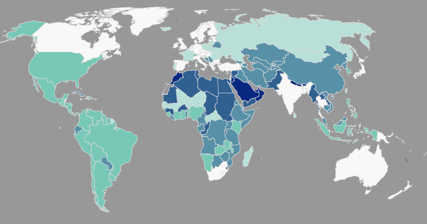
The World Freedom Atlas gathers a number of interesting datasets related to world politics and human rights and converts them into a dynamic map display. Interestingly, the visual display helps to foreground the rhetorical choices made by the authors of those datasets. For instance, the map below displays a country’s governmental structure, ranging from a parliamentary democracy (white) to monarchic dictatorship (dark blue) (Cheibub and Gandhi, 2004). Notice that the U.S., a presidential democracy, falls in the middle of the classification scheme, closer to the dictatorships than Canada and Australia, which are both white, as well as Russia, which is a light teal.
Tags:
ReplyYour contribution to the blog: Please Read Before PostingThe viz. blog is a forum for exploring the visual through identifying the connections between theory, rhetorical practice, popular culture, and the classroom. Keeping with this mission, comments on the blog should further discussion in the viz. community by extending (or critiquing) existing analysis, adding new analysis, providing interesting and relevant examples, or by making connections between that topic and theory, rhetoric, culture, or pedagogy. Trolling, spam, and any other messages not related to this purpose will be deleted immediately. Comments by anonymous users will be added to a moderation queue and examined for their relevance before publication. Authenticated users may post comments without moderation, but if those comments do not fit the above description they may be deleted. |
|
Recent comments
2 years 29 weeks ago
2 years 44 weeks ago
2 years 44 weeks ago
2 years 50 weeks ago
3 years 4 weeks ago
3 years 4 weeks ago
3 years 4 weeks ago
3 years 6 weeks ago
3 years 6 weeks ago
3 years 6 weeks ago