viz.
Visual Rhetoric - Visual Culture - Pedagogy
Site informationRecent Blog Posts
|
Many Ways to Map: The David Rumsey Map Collection Database
Submitted by Laura T. Smith on Mon, 2010-03-22 23:08
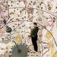
(Image Credit: David Rumsey Map Collection) Frances A. Henshaw, a student at the Middlebury Female Academy, created geographical diagrams like the one above to accompany her hand-drawn maps in her Book of Penmanship Executed at the Middlebury Female Academy April 29, 1828. According to the David Rumsey Map Collection Database, Henshaw’s Book of Penmanship went far beyond penmanship, including not only maps of 19 U.S. States with accompanying original diagrams (like the above), but also astronomical maps, charts of Coperican and Ptolemaic celestial systems, as well as maps of other prominent cartographic features such as equator, meridian, polar circles, latitude and longitude. Henshaw’s geographical diagrams seem to serve to illustrate or amplify the geographical data conveyed through her maps: reading in a diamond pattern (from the left and right upper diagonals, inward, then from the right and left lower diagonals, outward), the diagram reads:
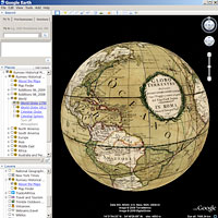
According to the Rumsey Collection, students commonly drew maps as part of their geography lessons, but Henshaw’s is a rare, extant example of this accompanying compositional and artistic activity. Interestingly, the figures that resemble ellipses and x’s in the diagram suggest the running stitches and cross-stitches native to a needlework sampler; in this way, the geographical diagram (included in a book of penmanship) seems to evoke the needlework samplers also frequently used to teach letters, spelling, and reading in early American schools. Henshaw’s diagrams, rare finds, are among the 20,000 cartographic artifacts collected, preserved, and made readily, digitally available through the David Rumsey Map Collection Database, another one of the exceptional image archives we’d like to draw attention to in preparation for our upcoming workshop on “Best Practices for Digital Images,” coming up this Friday, March 26th at 1 pm. The full Rumsey Collection, including all non-digitized items, includes over 150,000 items. The Collection has particularly strong holdings in rare 18th and 19th century maps of North and South America, but it has vast resources in many other areas as well. While the Collection began 25 years ago, digitization began in 1996. Information about the Collections’ newest acquisitions and features is available on the regularly updated blog. One of the strongest features of the David Rumsey Map Collection Database is the range of ways it allows viewers to view and download maps. All digitized resources are available for download in six to eight sizes, from small thumbnails to extra large, high-resolution files up to 12288 pixels. But the Rumsey Collection is perhaps especially astute in the methods it offers for viewing or browsing the Collection: the primary way to view the Collection is through the robust LUNA browser. (LUNA Imaging is also one of Rumsey’s projects.) The LUNA browser gives the researcher tremendous control of the browsing and searching experience, allowing her to select the size (small, medium, large) and number (50, 100, 250) of thumbnails that will be tiled on a page for browsing. Basic searches are allowed by resource type, map area, map creator, and map date, and advanced search functionality is also available. The Collection has also partnered with Google, Second Life, and Geographic Information Systems (GIS) to make Rumsey Historical Maps viewable in 3-D through Google Maps, Google Earth, and GIS maps.
(Image Credit: David Rumsey Map Collection) Lastly, the maps are viewable through a “Collections Ticker” that presents an ongoing horizontal stream of randomized map thumbnails. The ticker is a free-standing, thin horizontal bar that launches separately from the Map Collection and can stay on your screen while you work in other applications. It takes roughly eight hours for the entire Rumsey Database to scroll across the ticker. Tags:
|
|

Recent comments
2 years 29 weeks ago
2 years 44 weeks ago
2 years 44 weeks ago
2 years 50 weeks ago
3 years 4 weeks ago
3 years 4 weeks ago
3 years 4 weeks ago
3 years 6 weeks ago
3 years 6 weeks ago
3 years 6 weeks ago