viz.
Visual Rhetoric - Visual Culture - Pedagogy
Site informationRecent Blog Posts
|
Google Earth Pedagogies: From Haiti to RHE 306
Submitted by Laura T. Smith on Mon, 2010-02-08 13:41
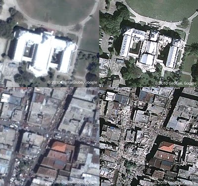
Image Credit: Google Lat Long Blog If were you watching the news in mid-January, you likely saw images like those above flashing repeatedly across your television or computer screen. Unlike the photojournalistic, street-level portraits that tend to document disasters, these aerial shots, produced through a collaboration between Google Earth and GeoEye (a satellite imaging company), have been prominent in the visual coverage of the earthquake that hit Haiti on January 12, 2010. The above images show pre- and post-quake views of the Presidential Palace (top left; top right) and downtown Port au Prince (bottom left; bottom right), and were created using the timeline tool in Google Earth. I’ve been interested in the prominent role that mapping and satellite-produced imagery has played in the coverage and documentation of the Haiti earthquake, partly for its own sake, and partly because I’m planning a Google Earth-based collaborative writing activity for my Rhetoric and Writing class this spring. In the earthquake coverage, the intimate, affect-laden portrait—framed by the human eye, scaled to the human story—has remained prominent, of course, but has been augmented by this second visual approach, which has, itself, received significant news coverage. These visuals do not function the same way photojournalistic visuals function; they do not focus on the human situation; they do not construct an explicitly emotional appeal. These sophisticated, accurate maps of damage have clearly aided rescue and relief efforts. Yet I’ve been wondering about the analytical impulses behind mapping and its effects—especially given the debates during the past few weeks about Haiti’s leadership, its autonomy, about who’s in control of relief efforts. The history of mapping is entangled with the history of imperial expansion, shot through with impulses toward geographical control. In what ways do these contemporary mapping technologies address or confront the imperial history of map-making? While much of the mapping of Haiti has been accomplished through satellite imaging, Haiti has also been mapped collaboratively, by countless individuals with diverse motivations. (Google’s Haiti Map Maker project encourages such collaborative, local mapping.) Similarly, Wikipedia’s “Haiti” page is currently ranked in 1885th place among the most-edited pages in the last 30 days, a number that, while seemingly high, in fact indicates an extraordinarily high volume of recent edits. So, what effect does crowd-sourcing have on the implications of mapping? Is crowd-sourced mapping anti-imperialist mapping? As I noted earlier, I’ve been considering all these questions about mapping and its implications because I’m in the process of planning a Google Earth-based collaborative writing activity with Geo-Everything’s Caroline Wigginton. We’ll be using Google Earth technologies to explore issues raised by Michael Pollan’s In Defense of Food. The activity, which will involve both of our RHE 306 classes, will take place in early April. In preparation for this collaboration, I’ll be using this blog throughout the spring semester to discuss Google Earth, its applications for the literature, rhetoric, and composition classroom, and, in particular, the potential it creates for collaborative writing. As I’ve begun to think through the possibilities, I’ve come up with a few initial questions, which I’ll address (and likely add to) in the coming weeks:
|
|
Recent comments
2 years 29 weeks ago
2 years 44 weeks ago
2 years 44 weeks ago
2 years 50 weeks ago
3 years 4 weeks ago
3 years 4 weeks ago
3 years 4 weeks ago
3 years 6 weeks ago
3 years 6 weeks ago
3 years 6 weeks ago