viz.
Visual Rhetoric - Visual Culture - Pedagogy
Site informationRecent Blog Posts
|
Critical Cartography: Aram Bartholl's "Map"
Submitted by Lisa Gulesserian on Thu, 2011-09-22 08:00
Image credit: Aram Bartholl's "Map" Google Maps is a godsend—in our daily lives, we use the site to find a new place to live, track the settings of a public controversy, catch lawbreakers in the act, and claim land that’s been long-contested. Border scuffles and all, Google Maps is helping us reimagine the terrains, cities, and spaces of the real world. It was only a matter of time before we witnessed the melding of Google Maps virtual and Real World spatial. That time is now: Berlin-based artist Aram Bartholl has spent the last five years working on a project that brings Google Maps’ digital location markers into real city spaces. His installations in different cities in Europe and Asia—all entitled “Map”—ask us to question the lines between real and virtual, center and periphery. Known for his work with “Dead Drops,” the USB sticks that were installed in bricks of urban buildings to encourage free and anonymous sharing, Bartholl has long been toying with the false dichotomy between digitized and lived experience. His art is a reminder that digital environments have their own spatial representations, and that these spaces have ramifications in our lived lives. With “Map,” Bartholl makes us question real and digital, center and periphery, through an installation involving a massive 600x350x35 cm wood sculpture of the iconic red location markers in Google Maps. With the help of a tow truck and a crane, the location marker was placed in the center of the city (two example locations for the installation were Taipei and Berlin).
Image credit: Aram Bartholl's "Map" From the pictures on Bartholl’s website, the markers are hard to distinguish from their digital counterparts. Both the digital markers and the “real” markers cast shadows. Both are perky punctuations in urban environments. Which of the markers is more real? Bartholl seems to nudge us in the direction of wondering whether this question matters anymore. To further drive home how much effect Google Maps has on our ideas about places, Bartholl’s city center is the one that Google Maps provides when you search for the city. That center could be in an intersection, in a verdant wooded area, or in a dilapidated housing complex. Whatever the case, Bartholl’s installation asks us to question our ideas of center and periphery. What if your idea of the center of Berlin is different than the center of Berlin in Google Maps? What does the “center” of the city even mean in a digitized world?
Bartholl’s work with the icons of Google Maps reminds us that maps are political productions. With maps, borders are drawn, districts are re-zoned, centers are marked. As geographers Jeremy W. Crampton and John Krygier argue in their “Introduction to Critical Cartography,” geographic knowledge is power, and hence, is political. With his cartographic installations, Aram Bartholl’s message is a political one; his work makes us rethink the boundaries that we have created when mapping digital and real, center and periphery, Google Maps or mental maps. Tags:
|
|
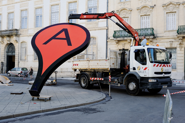
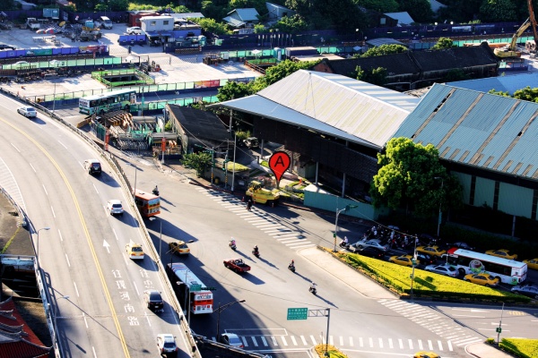
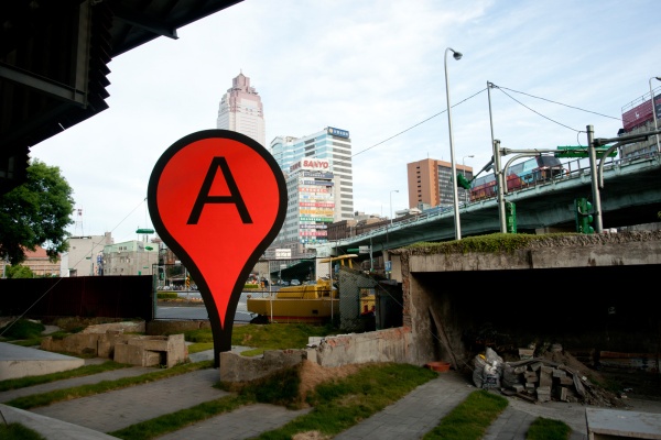 Image credit:
Recent comments
2 years 29 weeks ago
2 years 44 weeks ago
2 years 44 weeks ago
2 years 50 weeks ago
3 years 4 weeks ago
3 years 4 weeks ago
3 years 4 weeks ago
3 years 6 weeks ago
3 years 6 weeks ago
3 years 6 weeks ago