viz.
Visual Rhetoric - Visual Culture - Pedagogy
Site informationRecent Blog Posts
|
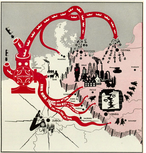
Cold WarThe Octopus of Antwerp and Other Cold War Maps: Critical Cartographies I
Submitted by Jake Ptacek on Tue, 2011-11-01 08:00
Image: Life Magazine via Newberry Library This is not the post I meant to write. My graduate research has increasingly involved reference to Charles Booth's Life and Labour of the People in London, a magisterial attempt to combine statistical data and cartography into an analysis of late-nineteenth century urban London experience. I had intended to post on Booth's groundbreaking "poverty maps", and the updated maps created by the London School of Economics (you can see their side-by-side comparison here). In my research for the post, though, I came across John Krygier's Making Maps blog, and I've become fascinated (and sidetracked) by the surprising power of cartography. Inspired to think about how maps and mapmaking critically constructs the world, what follows is a subjective and fairly non-rigorous tour of Western cartography during the Cold War era. Austin's Nuclear Family
Submitted by ebfrye on Sun, 2010-10-10 21:27
Image Credit: screenshot from Target Austin, via TAMI H/T: Dr. Randi Cox, Stephen F. Austin State Recently I attended the Cold War Cultures conference here at UT and had the pleasure of attending several especially provocative panels. Of particular interest was a talk by Stephen F. Austin State’s Dr. Randi Cox’s on Target Austin, a 1960 PSA film that localizes the threat of nuclear war by imagining an attack on the Texas capital. |
|

Recent comments
2 years 29 weeks ago
2 years 44 weeks ago
2 years 44 weeks ago
2 years 50 weeks ago
3 years 4 weeks ago
3 years 4 weeks ago
3 years 4 weeks ago
3 years 6 weeks ago
3 years 6 weeks ago
3 years 6 weeks ago