viz.
Visual Rhetoric - Visual Culture - Pedagogy
Site informationRecent Blog Posts
|
Google EarthReport from the Classroom, Part 2
Submitted by Laura T. Smith on Mon, 2010-04-12 22:48
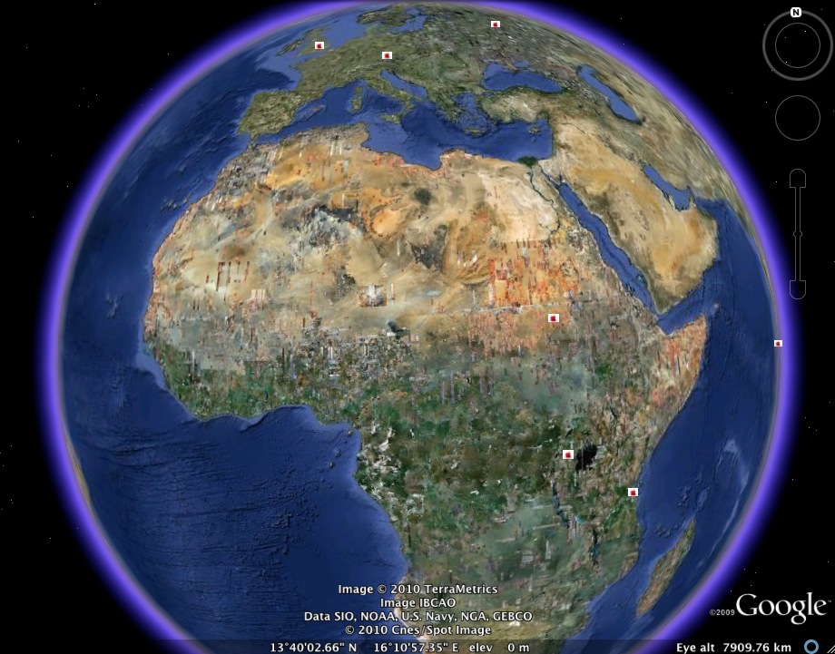
(Image credit: Google Earth map created by Smith's RHE 306) Caroline and I completed our Food Geographies Collaborative Writing Workshop last week. My students decided to keep their class map broad, not restricting it to Austin, to Texas, or to the United States. As a result, the geographies they trace are provocative, but also somewhat diffuse. That is, we might have gotten better results by densely mapping a limited area, but patterns emerge on our worldwide map that would not otherwise have been visible. While many students chose to map sites in the Austin area or the United States, the above map shows the efforts of two students who worked on mapping some non-U.S. sites, including major World Food Program sites, fast food locations in developing counties, and key sugar-producing sites. More detail on these sites and others, after the jump. Warren Avenue at 23rd Street, Detroit, Michigan
Submitted by noelradley on Tue, 2010-02-16 14:28
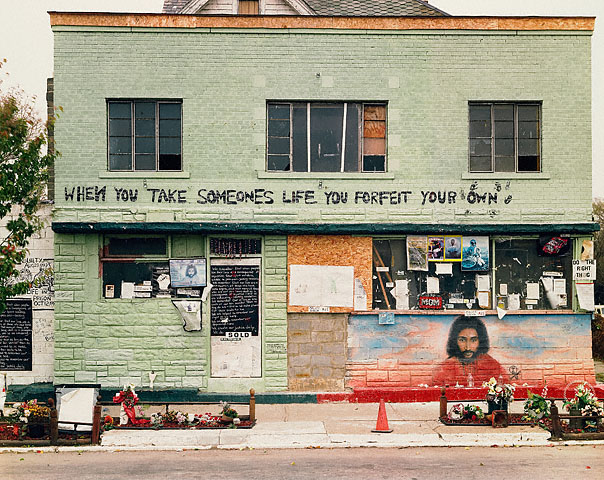
Image Credit: Joel Sternfeld Via The Getty H/T Seeing and Writing 3 For the past few years, I have started my course using the Joel Sternfeld photograph above. Class members usually list as many observations as possible, and then we start to hazard inferences about what this photo signifies...what the items of this environment present. I have a heart for this image. The scene invites us to narrate, but it also refuses to tell us the whole story (one part of which is the police beating and death of Malice Green in 1992). Today, I was reading Laura Smith's latest post on Googlemap pedagogy, and I wondered what would happen if I put in the address, which is also the title of the photo: "Warren Avenue at 23rd Street, Detroit, Michigan, October 1993."
Witness the artifact of the process
Submitted by Jillian Sayre on Sat, 2009-02-21 11:56
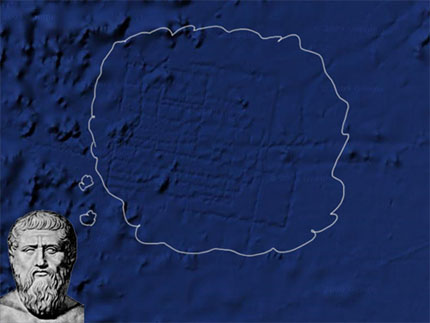
Derek Mueller over at Earth Wide Moth posted an interesting meditation on Google's recent mapping of the famously lost city of Atlantis. "The conspiracy doesn't interest me all that much. Instead, I'm struck by the impression: the stamp left by the "systematic" tracing, the residue of the surface-to-sea-floor method (a term others have smartly untangled it into meta-hodos or something like 'beyond ways', even 'ways beyond'; this etymological dig lingers with me). The deep blue grid of "bathymetric data" elicits questions: why don't we see these in the adjacent areas? What was it about this boat, this collection process, this translation from sound to image, that left behind the vivid trails?" Tags:
Swastika barracks
Submitted by John Jones on Tue, 2007-10-02 19:52
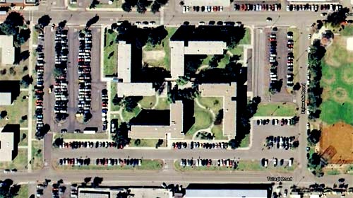
The image above was taken from Google Earth and shows the barracks at the U.S. Naval base in Corronado, California. Aparently the buildings are lovely from the ground, but from the air they’re, uh, offensive. The Navy is planning to spend “$600,000 for landscaping and architectural modifications” to alter the way the barracks look from the air. What I find interesting about this story is that Google Earth “created” this problem for the Navy. The technology literally allowed people to see this symbol. It reminded me of this passage from Jorge Luis Borges’s “The Aleph”: |
|
Recent comments
2 years 29 weeks ago
2 years 44 weeks ago
2 years 44 weeks ago
2 years 50 weeks ago
3 years 4 weeks ago
3 years 4 weeks ago
3 years 4 weeks ago
3 years 6 weeks ago
3 years 6 weeks ago
3 years 6 weeks ago